
Unprecedented Rainfall Hits the Rio Grande Valley: A Closer Look
Last week brought historic rainfall to the Rio Grande Valley, transforming dry landscapes into deluges of water almost overnight. This event highlights not only the unpredictable nature of Texas weather but also sets the stage for potentially dangerous weather patterns looming over the Midwest and Mid-South in the coming week.
Understanding Rainfall Forecast Variability
Leading up to the recent rain, meteorological models hinted at a disruption in the prevailing dry conditions that Texas has experienced for much of the year. This indicated a significant increase in precipitation chances, particularly focused in South Texas. By the time weather models reached their high-resolution forecasts, a clear possibility of heavy rainfall in South Texas emerged.
NOAA’s HREF model, released on Tuesday, forecasted a staggering 48-hour rainfall total exceeding 7 inches in areas including the Victoria Crossroads and Brush Country. Even deeper analysis revealed potential rainfall totals ranging from 10 to 15 inches, especially stretching from McAllen to Port Mansfield and up to Victoria. As Wednesday approached, predictions showed widespread maximum totals landing between 5 to 15 inches over a significant portion of South Texas.
HREF ensemble forecasts indicated potential flash floods across South Texas (NOAA SPC).
Upgrades in the excessive rainfall outlook on Thursday underscored a moderate risk (level 3 of 4) for the region, confirming that the path taken to enhance forecasts was justified. Initially, some models had pinpointed the Lower Rio Grande Valley just outside the moderate risk zone, but adjustments allowed for coverage to include it.
The Challenge of Precipitation Placement
Despite the strong signals for heavy rainfall, forecasting the precise location of precipitation remains a significant challenge in modern meteorology. Weather models notoriously struggle with the placement of rainfall during localized mesoscale events, which can lead to substantial discrepancies in predicted and actual rainfall locations. This time, the consensus leaned toward areas north of the Valley—near Corpus Christi and Victoria—while the actual rainfall hit Harlingen, which broke its all-time daily record by 3 inches.
Severe rainfall totals were recorded throughout the week, with Harlingen experiencing unprecedented levels for March, a month typically not known for heavy downpours. The same scenario played out for McAllen, with it becoming the third-wettest day on record. Unfortunately, this extreme weather event led to community damage and loss of life, as flood impacts are still being assessed on both sides of the border.
Forecasting Future Flooding Risks: An Eye on the Midwest and Mid-South
Looking ahead, the threat of flooding and severe weather is set to continue, particularly in the Midwest. The day five excessive rainfall outlook indicates moderate risk (3 out of 4) for much of the Ohio Valley. NOAA’s WPC has already issued warnings, with a forecast that anticipates repeating rounds of thunderstorms, potentially delivering significant rainfall accumulation in upcoming days.
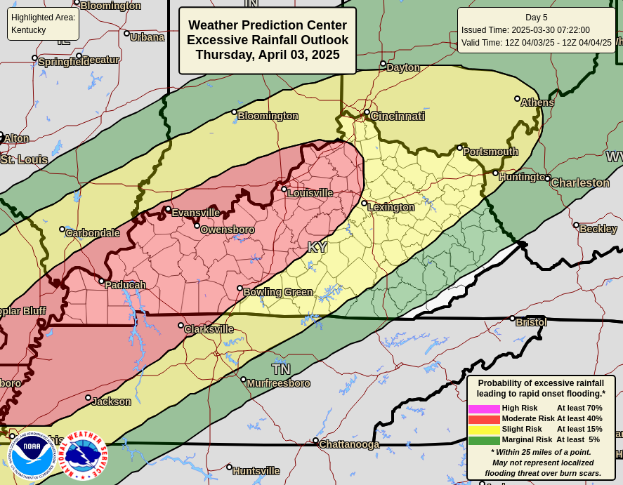
Moderate flood risk is anticipated across Ohio Valley regions (NOAA WPC).
As models project heavy rain, potential total accumulations may reach 4 to 8 inches, with some areas likely exceeding this estimate due to the historical underperformance of weather models in similar setups. The outlook for severe weather also indicates substantial risks, particularly for the Mississippi and Ohio Valleys.
Recent forecasts highlight the relationship between the evolving weather patterns and potential hazards. Supercell thunderstorms could develop, leading to strong tornadoes and damaging winds, while the Storm Prediction Center has raised concerns for widespread severe weather risks.
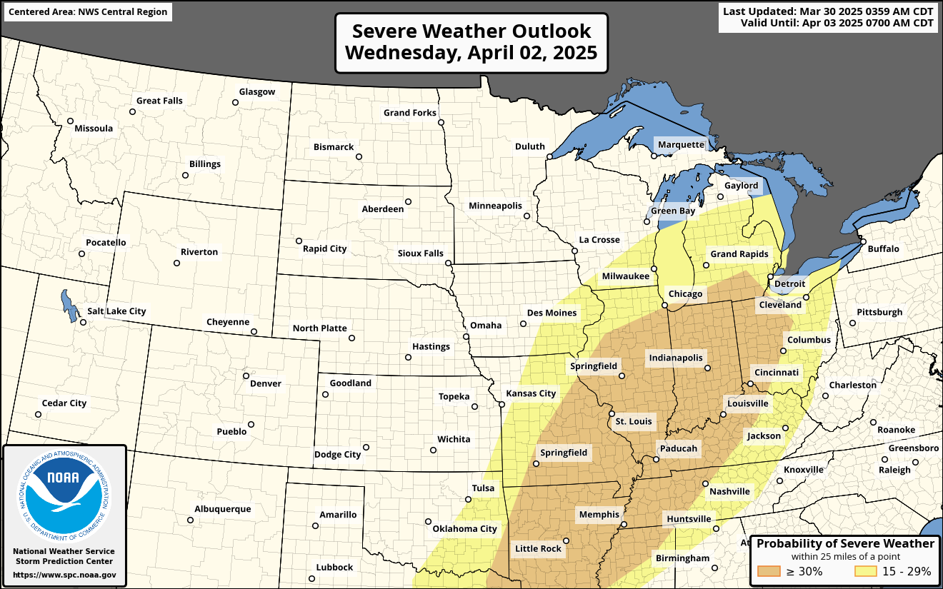
Severe weather risks are expected to increase significantly across various regions (NOAA SPC).
Conclusion: Staying Weather-Aware
In conclusion, both current events in the Rio Grande Valley and future weather threats in the Midwest emphasize the need for diligent monitoring and preparedness as changing weather patterns unfold. With total rainfall predictions ranging from 5 to 10 inches, residents in affected regions should remain alert.
As weather experts continue to hone their forecasting techniques, it’s crucial to stay informed and responsive to these dynamic conditions. For ongoing updates and detailed forecasts, follow local meteorological resources and emergency management services.
Additional Resources
By understanding and preparing for these challenges, communities can better mitigate the impacts of extreme weather events in the future.