Major Winter Storm to Impact Tri-State Area This Week
A powerful winter storm is on the horizon, set to deliver the first blizzard to the Tri-State area in nearly ten years. From Sunday afternoon to Monday morning, residents can expect significant snow accumulation, strong winds, and hazardous travel conditions that could disrupt transportation across New York, New Jersey, and Connecticut.
Blizzard Conditions Anticipated
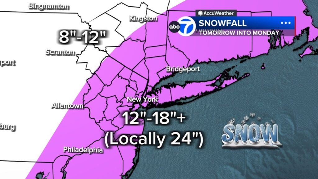
Meteorologists predict snowfall amounts between 12 to 18 inches across a vast region, with the potential for heavier, wetter snow that makes travel particularly perilous. Wind gusts exceeding 50 mph are expected, especially during the night, which could result in downed trees and power lines. In addition, coastal flooding is anticipated, with warnings indicating that water levels could rise by up to 3 feet during high tides.
The National Weather Service has already issued blizzard and winter storm warnings for New York City and surrounding areas. This storm might prove to be the most significant snow event since January 2016, which remains the largest snowstorm on record for NYC. Given that the last blizzard warning was in March 2017, this upcoming event is unique.
Saturday: Calm Before the Storm
As residents prepare for the incoming weather, Saturday will offer a brief reprieve. Expect cloudy skies with mild temperatures in the mid to upper 40s. This day serves as a good opportunity for residents to finalize their storm preparations.
Sunday: Snow Begins
The weather will take a dramatic turn starting Sunday morning. Light snowfall is anticipated, though initial temperatures may hover just above freezing, limiting early accumulation to potentially a slushy inch. As the day progresses and temperatures drop, snow accumulation will become more substantial.
Peak Impact Sunday Night into Monday
The storm’s intensity will peak late Sunday evening and carry through to Monday morning. Snowfall rates may climb to 2-3 inches per hour, creating whiteout conditions particularly along coastal areas. The storm’s pressure will approach that of a category 2 or 3 hurricane, but as it encounters colder air, precipitation will shift entirely to heavy snow.
Blizzard warnings are in effect for several regions, including:
- Long Island
- All five boroughs of NYC
- Westchester and Rockland Counties
- Coastal Connecticut
- Much of New Jersey
A Blizzard Warning indicates winds or gusts will meet or exceed 35 mph, leading to reduced visibility of 1/4 mile or less for three hours or more.
Snowfall Projections
By the end of the storm on Monday, it is expected that many areas will see between 12 to 18 inches of snow. In certain regions, notably the East End of Long Island and parts of the Jersey Shore, totals could exceed 20 inches due to persistent heavy bands of snow.
Timeline of Events
- Saturday: Cloudy and mild; highs in the 40s—ideal for storm prep.
- Sunday Morning: Light snow begins; minimal accumulation anticipated.
- Sunday Afternoon: Temperatures drop; steadier snow makes an appearance.
- Sunday Evening/Monday Morning: Peak storm impact; heavy snow combined with dangerous wind gusts.
- Monday Midday: Snow begins to taper off while wind persists.
- Tuesday: Cold temperatures with residual snowcover.
- Midweek: A slow thaw begins.
Officials warn residents to complete their preparations on Saturday and to avoid any non-essential travel from Sunday evening through Monday morning.
Additional Resources
Stay updated on the latest conditions by checking resources such as AccuWeather, where snowfall projections will be regularly revised as new data emerges. Preparedness is key during such winter events; familiarize yourself with local emergency management guidelines to ensure safety throughout the storm.
As this powerful winter storm approaches, remain vigilant and take appropriate safety measures to navigate the changing conditions.


