Texas Weather Alert: An Active Week Ahead
As Texas prepares for a week of dynamic weather patterns, residents can expect significant activity across the state. An active upper-level jet stream is influencing conditions, with quiet weather for Monday followed by a noticeable uptick in activity starting Tuesday.
Increased Wildfire Risks
On Tuesday, the western half of Texas will face critical to extreme wildfire danger. According to the Texas Storm Chasers, conditions are ripe for wildfires, necessitating caution from residents in these areas. As the day progresses, an isolated severe storm may emerge east of the dryline in Northwest Texas and the Big Country, particularly late in the afternoon. While the probability is low, any storm that does form risks producing significant hail.
Conditional Threat of Severe Storms
As Tuesday night approaches, the chance of scattered storms increases due to enhanced upper-level lift. However, confidence in storm development remains low, especially south of the Red River. Should storms materialize, conditions would be conducive to severe weather, with potential for large hail, damaging winds, and even a tornado risk. Continuous monitoring will help refine predictions and keep the community informed.
Forecast from Wednesday to Saturday
From Wednesday through Saturday, Texas will experience multiple rounds of thunderstorms, driven by a stationary front and abundant upper-level lift. Areas including Texoma, North Texas, Northeast Texas, and East Texas should prepare for the likelihood of severe storms, as the forecast indicates potential for large hail, damaging winds, and heavy rainfall.

It’s essential to understand that while some storms may reach severe levels, not every storm will be intense nor will it rain continuously. Rain chances will spread throughout much of Texas as the week progresses, though regions like Big Bend, South Texas, and the Coastal Bend could see lesser impacts.
Rainfall and Flooding Concerns
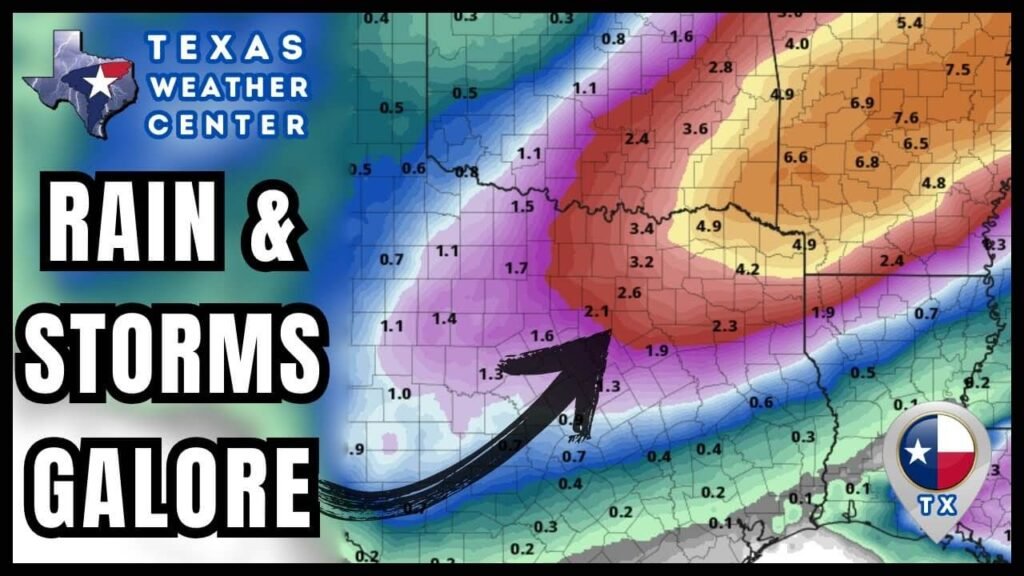
Heavier rainfall is anticipated across large portions of Texas, particularly in Northeast Texas and the Ark-La-Tex, which may receive between three to seven inches by Saturday. Such levels raise concerns of localized flooding by Thursday and Friday. A detailed rainfall forecast can provide insights into potential impacts in your area.

As the week wraps up, there is even a possibility of snow mixing with rain across the Panhandle and West Texas, depending on the trajectory of an upper-level storm system.
Conclusion
In summary, Texas is bracing for an active week of weather, ranging from critical wildfire conditions to severe thunderstorms and potential flooding. Residents are encouraged to stay informed and prepared for changing weather conditions as the week unfolds. For further updates and specific alerts, keep an eye on local weather channels and the National Weather Service.


