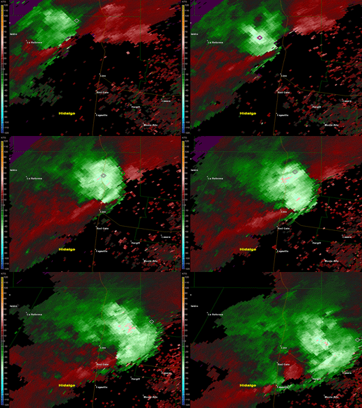
Severe Thunderstorms Strike Northern Hidalgo County: A Detailed Report
On the afternoon of May 8, 2012, a series of severe thunderstorms swept across northern Hidalgo County, affecting areas along and near Highway 281. Radar data from the event revealed estimated wind gusts just below 70 mph at approximately 5,500 feet above ground level. These turbulent conditions crossed the highway around 5:11 PM CDT, resulting in significant damage in the vicinity.
Thunderstorm Development
The chaos began early in the day as a slow-moving upper-level disturbance traveled through the southwestern United States. Initial thunderstorm activity ignited the Sierra Madre Oriental in the morning, subsequently shifting towards the Rio Grande Plains by noon. This was further enhanced by an approaching wind shift line descending from the South Texas Plains. The atmosphere was highly unstable due to a combination of cold, dry air aloft and warm, humid conditions near the surface, leading to explosive thunderstorm development.
By lunchtime, residents of Zapata County experienced damaging winds, sizeable hail, and torrential downpours. As conditions continued to evolve throughout the afternoon, the contrast between the cool air to the north and the lingering warmth of the Rio Grande Valley—where temperatures touched the 90s—promoted more intense storms. A particularly formidable supercell thunderstorm emerged, moving from Brooks County through Raymondville before gradually weakening.
Damage Reports
The supercell was noted for its impressive structure and destructive winds. Fortunately for the heavily populated middle Valley, the storm veered north of the critical SR 186 and U.S. 281 interchange, allowing it to travel quickly through the Lower Rio Grande Valley National Wildlife Refuge. By the time it reached Raymondville, the storm had significantly diminished in intensity but not before causing noteworthy impacts.
Summary of Damage
-
Wind Gusts: The storm registered an instantaneous gust of 102 mph at a temporary wind platform, with sustained winds of 50 mph lasting for about 35 minutes.
-
Injury: A truck driver was injured when the trailer he was towing overturned on the side of U.S. 281 due to blinding rain and hail.
-
Property Damage: Numerous homes in the vicinity reported damage, including a ranch located approximately one mile from the truck incident, where the precinct Constable noted significant storm-related impacts. Asphalt shingles were ripped off roofs, windows were blown out, and several trees—including mesquite, ebony, and oak—sustained damage.
-
Infrastructure: Heavy cables were torn from a nearby telephone tower, estimated to be 200 feet high.
- Rainfall: Rain gauges across the ranch showed totals ranging from 4 to 4.5 inches, leading to standing water along unpaved roads and fields.
Additional Incidents
The storm’s ferocity resulted in multiple reports of damage throughout the day. A preliminary report from the National Weather Service cataloged various incidents, including heavy rainfall and wind gusts.
- 12:11 PM: San Ygnacio experienced heavy rain with reports of over an inch.
- 1:03 PM: Winds in Zapata reached 62 mph, causing multiple trees to come down.
- 3:35 PM: Flooding was reported, with moving water reaching up to 3 feet in streets around Zapata.
Conclusions
The severe thunderstorms on May 8, 2012, serve as a stark reminder of the power of nature and the potential for weather-related disasters. The combination of high winds, heavy rains, and mixed precipitation created a high-impact event, particularly for the residents of northern Hidalgo County.
In conclusion, understanding storm dynamics and remaining informed during weather events is vital for safety and damage mitigation. For ongoing weather updates and safety information, follow NOAA or your local meteorological services.
Related Articles:
By staying educated and prepared, communities can better navigate the challenges posed by severe weather events like the one experienced on May 8, 2012. Stay safe and vigilant.


