Arctic Blast Approaches the Rio Grande Valley: What to Expect
As the Arctic blast heads toward the Rio Grande Valley, the First Warn 5 Weather Team is diligently monitoring the situation. Detailed forecasts indicate that the cold front will arrive earlier than initially anticipated, bringing significant temperature drops and some potential spotty showers.
When Will the Cold Front Arrive?
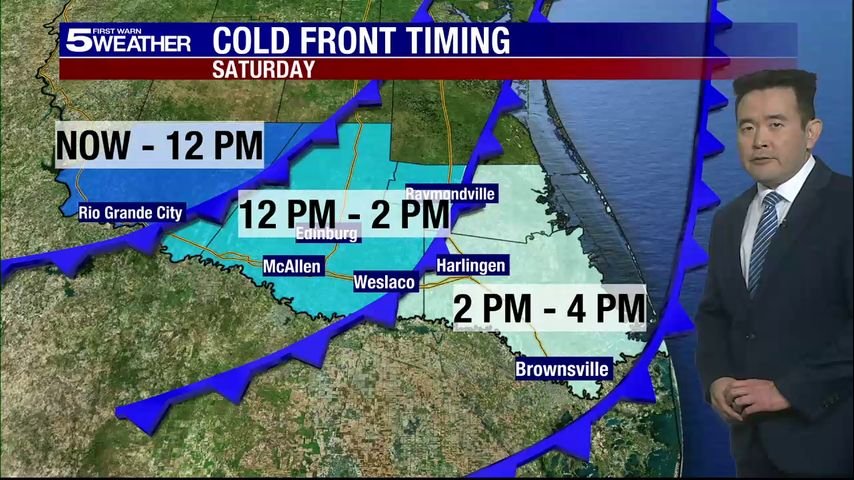
The current projection for the arrival of the cold front is as follows (with a window of plus or minus one hour):
- Roma: 10 a.m. on Saturday
- McAllen: 12 p.m. on Saturday
- Brownsville: 3 p.m. on Saturday
These timings suggest a swift advance of chilly air across the region.
Saturday’s Weather Forecast
Before the cold front sweeps through, Saturday will feature relatively mild weather. Expect daytime highs in the mid-70s, particularly before noon. However, as the day progresses, temperatures will begin to drop significantly. By early afternoon, expect a decline into the 50s, eventually plunging into the 40s by late afternoon.
Breezy Conditions: Wind gusts are anticipated, adding to the chill as the day goes on.
Rain and Shower Prospects
Spotty showers are a possibility on Saturday afternoon and evening as the cold front arrives. Rain chances will be elevated particularly along the coast, but any precipitation should diminish by Sunday afternoon, leaving a brisk and cool end to the weekend.
Freezing Temperatures Ahead
While wintry precipitation isn’t expected in the Valley, the forecasts suggest that the coldest temperatures will occur on Monday morning. Many areas in the Valley could see temperatures near or below freezing for a few hours. Specific locations like Rio Grande City, Raymondville, and ranchlands in northern Hidalgo and Starr counties could experience brief dips into the upper 20s or low 30s.
Additional Cold Spells
Temperatures will remain frigid on Tuesday morning, with Weslaco likely reaching freezing conditions. Areas farther north, including Edinburg and other ranchlands, could experience even colder temperatures.
Key Precautions: The 4 P’s
With the threat of freezing temperatures, ensuring the safety of people, pets, plants, and pipes is crucial. Here are recommended actions:
- People: Dress warmly and avoid prolonged exposure to the cold.
- Pets: Provide warm shelter to ensure their comfort.
- Plants: Consider bringing sensitive plants indoors.
- Pipes: Allow faucets to drip overnight to prevent freezing.
Understanding This Cold Snap
It’s essential to note that this cold front isn’t comparable to the severe winter event of February 2021. No frozen precipitation is expected this time around, and the freezing temperatures should be brief and localized. This makes it a more typical winter cold snap for the Valley.
Stay Updated with the Latest Weather Information
For ongoing updates regarding the developing weather situation, consider downloading the KRGV First Warn 5 Weather app.
You can also follow the KRGV First Warn 5 Weather Team on Facebook and Twitter to remain informed.
As we prepare for this Arctic blast, keep an eye on the changing weather and take the necessary steps to protect yourself and your belongings against the cold.


