Arctic Blast Alert: What to Expect in the Rio Grande Valley
As winter weather takes a significant turn, the First Warn 5 Weather Team is on high alert. An Arctic blast is set to sweep across the Rio Grande Valley, and it’s anticipated to arrive earlier than initially forecasted. If you’re in the area, it’s essential to be prepared for the changes ahead.
Timetable for the Cold Front
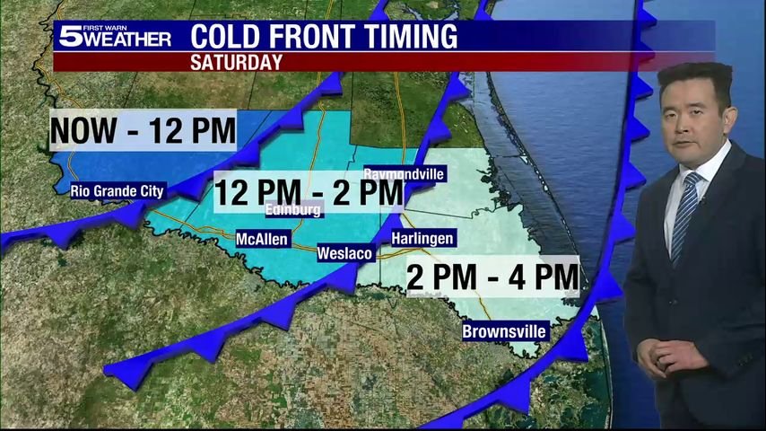
The cold front’s arrival is projected as follows, though these times may vary slightly:
- Roma: Around 10 a.m. Saturday
- McAllen: Approximately 12 p.m. Saturday
- Brownsville: By 3 p.m. Saturday
Saturday Weather Overview
Saturday promises to be mild initially, with temperatures soaring into the mid-70s in the morning. However, as the day progresses, expect a sharp decline in temperatures. By early afternoon, readings will drop into the 50s, eventually falling to the 40s by late afternoon. The air will become noticeably chilly, accompanied by breezy conditions.
Rain Possibility
Some isolated showers may develop Saturday afternoon and continue into the evening. Coastal areas might experience slightly higher chances of rain overnight, but conditions are expected to improve, with showers tapering off by Sunday afternoon.
Coldest Temperatures Ahead
The coldest weather is projected for Monday morning, with many areas in the Valley, including Rio Grande City, Raymondville, and the northern ranchlands of Hidalgo and Starr counties, potentially dipping into the upper 20s or near 30 degrees for a brief period. This quick drop in temperature could feel quite stark after the milder conditions.
Tuesday’s Freeze
Residents should also be aware that another chilly morning awaits on Tuesday, particularly in Weslaco, where temperatures may graze the freezing mark. Expect the coldest spots to be Edinburg, Raymondville, Rio Grande City, and ranchland areas, where temperatures will likely be a few degrees lower.
Preparations are Key
Given the potential for freezing temperatures, the “4 P’s” are crucial:
- People: Stay indoors and dress warmly.
- Pets: Provide shelter to keep them warm.
- Plants: Bring sensitive plants indoors to protect them from the cold.
- Pipes: Drip your faucets overnight to prevent freezing.
Not a Repeat of February 2021
While the forecast is alarming, this weather event is expected to differ significantly from the extreme conditions experienced in February 2021. No frozen precipitation is anticipated, and any freezing temperatures are expected to be brief and localized, rendering this a typical winter cold snap for the Valley.
For ongoing updates on this weather situation, consider downloading our free KRGV FIRST WARN 5 Weather app to receive live alerts directly on your mobile device.
Stay connected with the latest weather forecasts by following the KRGV First Warn 5 Weather team on Facebook and Twitter.
By staying informed and prepared, you can ensure you navigate this cold blast safely and comfortably.


