
Labor Day Weekend Weather in Texas: Storms and a Cool-down
Unseasonable Weather Forecast
Labor Day weekend is shaping up to be an unusual experience across Texas, with weather conditions resembling October rather than late August. A significant cold front and successive storm systems are set to sweep through the state, leading to thunderstorms, flash flooding, and a notable drop in temperatures.
Immediate Flash Flood Alerts
As of late Friday morning, numerous areas in East and Northeast Texas have already experienced flash flooding. Communities, particularly near Gilmer, received over nine inches of rain overnight, prompting multiple flash flood warnings in regions such as Longview, Tatum, Carthage, and Center.
Daytime storms pose significant flooding risks across East Texas; overnight showers may heighten flooding chances in the Panhandle and West Texas.
Residents have reported street flooding, creek overflow, and inundation in low-lying areas, with additional rainfall expected as the evening progresses.
Friday Night to Saturday Morning Storms
A powerful cluster of storms is projected to move from New Mexico into the Texas Panhandle and West Texas overnight. These storms could generate wind gusts exceeding 65 mph, frequent lightning, heavy precipitation, and occasional hail. By Saturday morning, these weather systems are anticipated to extend into Northwest Texas, the Big Country, and parts of North Texas.
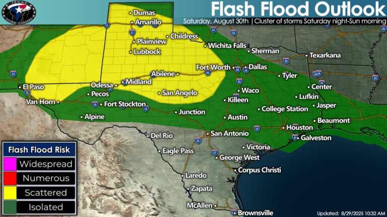
Potential for scattered flooding exists from the Panhandle through West Texas, Big Country, and San Angelo.
Meanwhile, scattered storms are likely to persist in Southeast Texas and the Piney Woods, with some of these storms possibly turning severe, featuring gusty winds and small hail.
Weekend Showers: A Repeated Pattern
On Saturday afternoon and into the evening, thunderstorms are expected to redevelop along a persistent cold front stretching across West, Central, and Southeast Texas. Additional storm complexes may form overnight into Sunday morning, increasing the risk of flooding.
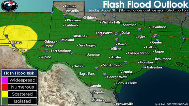
Thunderstorms to continue on Sunday, with isolated flash flooding risks evident in Far West Texas.
By Sunday, various thunderstorms will likely affect much of Texas, particularly escalating the flash flooding risk in Far West Texas and border areas.
Rainfall Predictions Through Midweek
Over the next five days, rainfall is expected across most of Texas. A widespread accumulation of 1–3 inches is anticipated, with localized amounts of 2–4 inches possibly impacting the Big Country, Concho Valley, Hill Country, North and Central Texas, and the Golden Triangle.
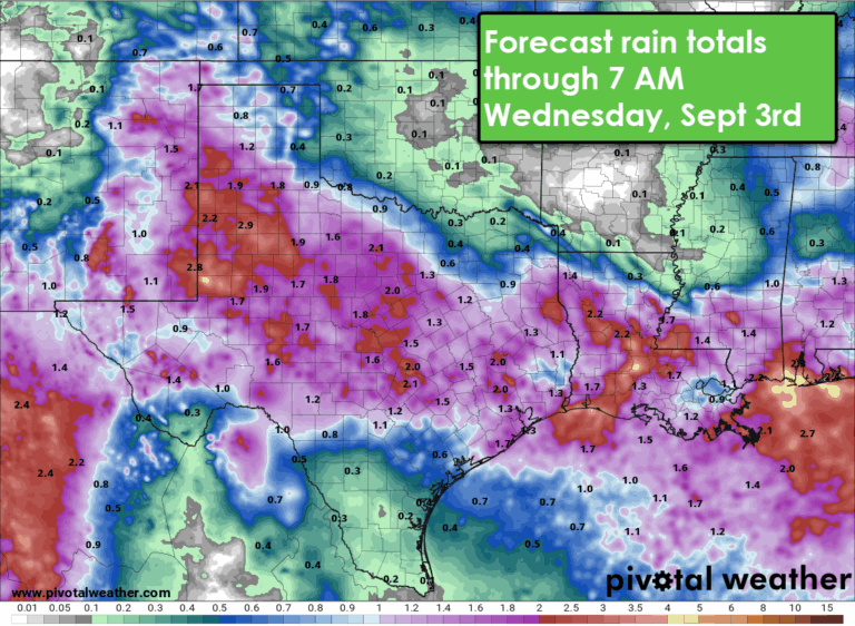
Forecast rainfall projections through September 3 show widespread 1–3 inch totals, with some areas experiencing heavier rainfall.
Intense rainfall could lead to localized flash flooding, especially in regions that face repeated storms.
A Refreshing Temperatures Shift
Although Friday temperatures are expected to soar above 100°F in cities such as San Antonio, Austin, Laredo, and the Rio Grande Valley, cooler air has already started filtering into Northeast Texas.
-
Saturday: Highs in the 70s and 80s across Northeast Texas, while South Texas and Rio Grande Plains remain exceptionally warm in the triple digits.
-
Sunday: Northern Texas temperatures will range from the upper 70s to low 80s, contrasting with continued heated conditions in South Texas, likely nearing 100°F.
- Monday: Most of the state will maintain highs in the 80s, while South Texas will see slight cooling, still hovering around 100°.
This cold front won’t completely close the chapter on summer but will bring a refreshing taste of fall-like weather for many Texans as they move into September.
Anticipating Future Storm Patterns
The trend of nighttime storm systems moving into Texas may remain consistent into early next week. While Monday is anticipated to be less active, another round of storms could emerge by midweek. Cooler weather and enhanced rainfall chances are projected to persist into early September.
For real-time weather updates, radar tracking, and storm warnings, consider utilizing the Texas Storm Chasers mobile app or explore the interactive radar at Texas Storm Chasers Radar.
Ensure you stay informed and prepared as Texas navigates through this uniquely storm-laden Labor Day weekend.