Texas Winter Weather Update: What to Expect This Weekend
Texas residents will experience a brisk reminder that winter is still very much ongoing this weekend. While last week brought a hefty winter storm, the current cold front sweeping through the state promises a more manageable weather situation—one without the ice and snow disruptions that plagued many Texans.
Impact of the Recent Cold Front
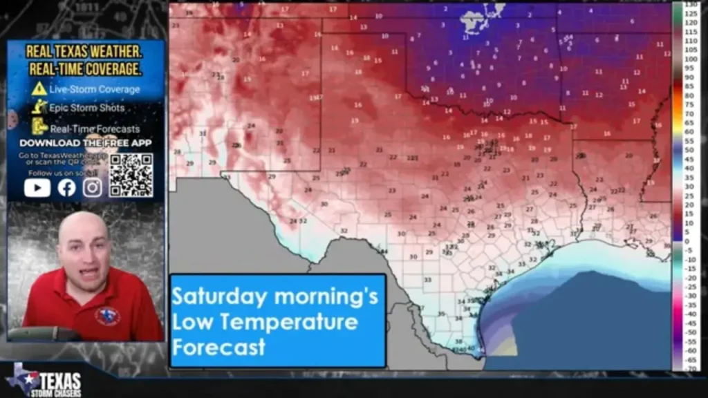
Late Thursday night into Friday morning, a cold front ushered in a wave of north winds and significantly cooler temperatures. A reinforcing surge of chilly air is forecasted tonight and into Saturday, which will keep Texas feeling breezy and cold throughout the weekend. However, a notable distinction lies in the absence of winter precipitation: there is no ice or snow forecasted this time around.
Conditions Across Texas
In the wake of the front, expect an increase in north winds lasting through Saturday, especially impacting areas in North Texas, West Texas, and the Panhandle. Although this air mass is cooler, it lacks the severity of last week’s Arctic weather event.
Saturday Forecast
Saturday promises to be the coldest day in this stretch, as high temperatures may not surpass freezing in certain areas of North Texas and Texoma. However, the majority of Texas will remain cold and, crucially, dry. Wind chills will further lower the temperature feel, particularly in northern regions.
Sunday morning is likely to bring yet another widespread freeze, with most parts of the state starting off below freezing. However, South Texas and the Rio Grande Valley should stay just above this threshold.
No Winter Weather to Worry About
Unlike the recent winter storm, the current system is dry, offering no threat of freezing rain, sleet, snow, or freezing fog. Road conditions should remain dry, and no substantial travel issues are anticipated. The focus will be on cold temperatures rather than hazardous precipitation—a welcome shift after recent weather disruptions.
Fire Weather Alerts
Despite the recent drop in temperatures, fire weather remains a concern. Dry grasses combined with gusty north winds will heighten fire danger, particularly in South Texas, the Rio Grande Plains, and parts of the Gulf Coast. Although fire danger is expected to remain low to moderate, conditions can shift rapidly. Therefore, outdoor burning is strongly discouraged, especially today and Saturday.
Looking Forward: Warming Trends Ahead
Beginning Sunday, a shift in weather patterns will occur as winds shift back to the south. This change will foreshadow a gradual rise in temperatures, with a more pronounced warm-up anticipated on Monday.
Weather Expectations for Early Next Week
By the start of next week:
- Much of Texas will see temperatures climb back to the 60s and 70s.
- South Texas may even experience highs approaching or exceeding 80 degrees.
- Overnight freezing conditions will become less common.
This brief warming trend will serve as a refreshing change after the recent cold snaps.
Upcoming Rainfall Forecast
Looking ahead, Texas could see its next significant chance of rain Tuesday into Wednesday, particularly focusing on areas across East Texas, Southeast Texas, and the Brazos Valley. While anticipated rainfall amounts will be light to moderate, much of West Texas is expected to remain dry—and no severe weather or winter precipitation is expected.
Key Takeaways for Texans
- Expect cold and windy conditions persisting through Saturday.
- No winter weather impacts are expected this weekend.
- A widespread freeze is likely on Sunday morning.
- A warming trend will begin on Sunday, gaining momentum on Monday.
- The next chance of rain will arrive midweek, primarily affecting eastern regions.
For real-time updates on changing conditions, temperatures, and rain forecasts, check the free Texas Storm Chasers mobile app or visit Texas Storm Chasers.
Stay warm, and if you’re stepping out, dress accordingly to combat the chill!


